To ensure comprehensive and holistic watershed characterization and vulnerability assessments in Region X, a four-day training on Carrying Capacity and Coastal Vulnerability Assessment was conducted by the Ecosystems Research and Development Bureau (ERDB) through the Department of Environment and Natural Resources (DENR), Region X on October 18-21, 2022 in Cagayan de Oro City.
DENR X Regional Executive Director Henry A. Adornado, PhD said that the training aimed to understand the concept of carrying capacity and urban biodiversity. He added that learning these concepts will guide to generate science-based decisions, which is vital in the formulation of Environment and Natural Resources plans as well as in the execution of DENR mandates. He imparted that it is also in line with the directive of DENR Secretary Ma. Antonia Yulo-Loyzaga to work closely with the local government units.
Assistant Regional Director for Technical Services Felix S. Mirasol, Jr. as represented by OIC, Chief Conservation Development Division Fidel P. Gamos, Jr. said that the training will capacitate the participants on coastal vulnerability assessment and integrate its result to develop appropriate programs and projects in the formulation of Integrated Watershed Management Plans. He added that understanding coastal vulnerability assessment will also enable them to identify efficient climate change mitigation and adaptation strategies and enhance the information during Communication, Education, and Public Awareness activities.
A total of 43 participants joined the training composed of DENR X Regional and field offices Geographic Information System (GIS) specialists, Conservation and Development Division staff, representative from Bureau of Fisheries and Aquatic Resources X, Department of Tourism and the local government of Alubijid, Misamis Oriental.
The ERDB Team was split into two teams, namely: Carrying Capacity Team headed by Senior Science Research Specialist Paulina Rowena C. Payuan and the Vulnerability Assessment Team headed by Science Research Specialist II Annieraj Velasco to efficiently facilitate the discussion of lessons and series of workshop and practical activities. The ERDB team discussed about the Storm Surge and Coastal Erosion Vulnerability of Coastal Areas within the Priority Watersheds in the Philippines and also shared about Model Generation for Beach Profile, Data Assembly for Adaptive Capacity, Data Encoding and Processing. The GIS specialists were taught on the creation of coastal strip, creation of polylines and computation of shoreline change and Vulnerability Assessment Map generation.
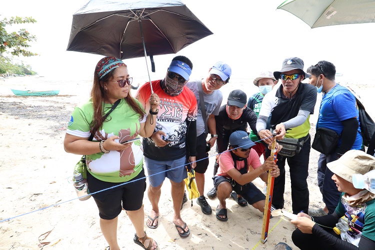
A fieldwork was conducted during the training through a site visit and field observation, beach profiling, mangrove assessment and documentation of adaptive capacity in the municipality of Laguindingan, Misamis Oriental.
Generated results from assessments on Carrying Capacity, Urban Biodiversity and Coastal Vulnerability will serve as input to regional, sectoral and local spatial planning in addressing environmental degradation caused by rapid population growth, urbanization, and intensified agriculture including the effects of climate change and human activities that can add up to the pressure on these natural resource ecosystems. (RSCIG No. 10-320-2022 #TayoAngKalikasan)
- Details
- Parent Category: News & Events
- Category: Press Releases
- Published: 26 October 2022